|
| Sedona - Courthouse Butte Trail |
| Rating | ***** |
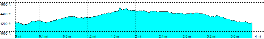
| length | 4.1 mile - 1 hour 45 minutes (round trip). Moderate. |
| Height | 4180 - 4500 feet |
| Access | All Cars, all paved. Highway 179, After the last roundabout north of Oak Creek, park at the very large parking lot of Bell Rock. |
| Other Trails | Meets: Llama loop trail and Rabbit Ears trail |
| Data | To download these files, right-click the link and choose 'save as' |--| .GPX (GPS file) |-----| .KML (Google Earth file) |