Borrego Springs picture
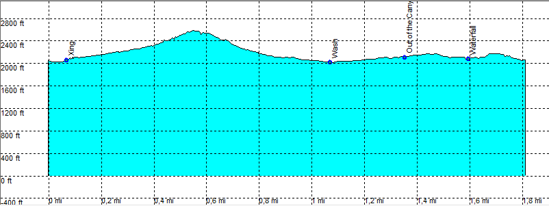
Borrego Springs: Lizard Canyon

Rating *****
length 1.9 mile - 2 hour 05 minutes (round trip). Moderate.
Height 2020 - 2580 feet
Access Mile 75,9 HW 78, (sign Lizard Wash). AWD, or start you hike here
Other Trails
Data To download these files, right-click the link and choose 'save as' |--| .GPX (GPS file) |-----| .KML (Google Earth file)

  • Back

  • Take the dirt road (AWD) Until you reach the end of the dirt road.
    This hike is mostly cross country.
    Hiking into the canyon we take the left fork.
    A lot of barrel cacti (blooming in March).
    As we go out the canyon to the right, go down another canyon on a more challenging path downhill.
    Follow the canyon to the wide wash below.
    Enter another canyon to the right in the direction of the trailhead.
    We have to go back when we reach a drop we can't pass.
    Going a bit back, take the right canyon and out of the canyon over the top into the final canyon back to the trailhead.
    Hiking time 2.05 Hours return.


    Efmer_Borrego_lizard_canyon

    Disclamer: Read this first before you start your hike.
    Contact: usa/at/e/f/m/e/r/.eu (leave out the /)
    All hikes recorded on pocket loox (pocket PC) using gpsTuner(.com)
    Hiking Hellhole Canyon Trail Borrego Springs Area (Anza-Borrego Desert State Park) California, Hike with gps, gpx and kml (Google Earth).