|
| Prescott - 37 Little Granite Mountains Trail |
| Rating | ***** |
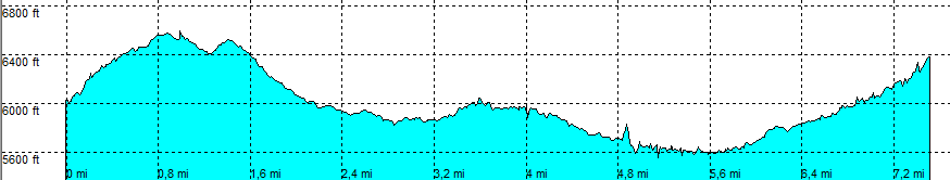
| length | 7.5 mile - 4 hour 10 minutes (round trip). Hard. |
| Height | 6020 - 6560 - 5600 - 6550 feet |
| Access | All Cars, all paved. On Iron Springs road, park in the parking area on the right hand side. Mile 6, west of Prescott |
| Other Trails | Close to Granite Mountain Trail |
| Data | To download these files, right-click the link and choose 'save as' |--| .GPX (GPS file) |-----| .KML (Google Earth file) |