Borrego Springs picture
Borrego Springs: Whale Peak North

Rating *****
length 
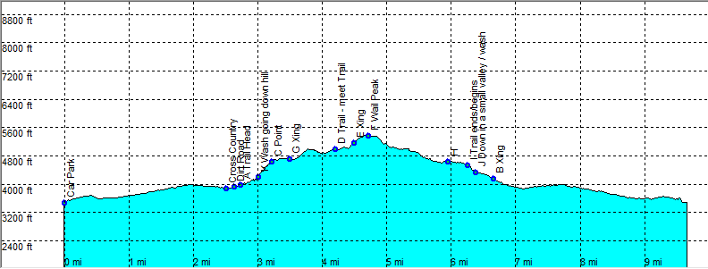
4.4 mile (trail head) or 10 mile - 4 hour, add 1 hour 30 minutes from the point we started (Round trip).The way up takes about 1/2 hour longer than the return trip. Moderate.
Height 3900 - 5350 feet
Access On Hwy 2 after mile 21 and directly after the Anza Borrego Park sign (from the direction of Borrego Springs) head left on a dirt road. High clearence Car recommended.
Other Trails
Data To download these files, right-click the link and choose 'save as' |--| .GPX (GPS file) |-----| .KML (Google Earth file)

  • Back

  • This is the other way to climb Whale Peak. This is the shortest one, if you are lucke enough to make it to the trail head, that is.
    Head East at the sign Pinyon mountain valley. Follow this dirt road in a high clearance 4x4 to the trail head, or as far as you can make it.
    We made it up to the mark Parking, this is a short rocky stretch, too much for our 4x4 car because of the clearance.
    At the trail head, go into the gorge/canyon and hike up a rocky trail. If you can call it a trail that is, there have been other people and there are cairns.
    Be careful the cairns only indicate that someone else made it this far, it is not necessarily the easiest way. At point B we took the more direct route up (south, a bit to the left).
    The other way to the right (west) is easier but hard to find without knowing exactly where to go, but with a gps it should be easy to find.
    Up to point C you made the steepest climb. Head further cross country (expect large rocks and boulders, some huge) and aim for point D.
    At point D we hit the trail and a good one leading up to the peak (east) This goes really fast all of a sudden.
    Follow this trail to point E. At this point the actual short but steep climb to the flat top starts.
    Look around to make sure you get back the same way you came. The view is stunning as you can probably see most of the park on a clear day.
    The way back is a good trail up to point I, after this point the trail goes down (rocky and steeper) there are some cairns, but there are many ways leading down.
    At point J there is a flat sandy valley. Take the wash east and keep left in the wash that gets more narrow.
    At point K the wash goes downhill more steeply, by keeping a bit left we found our way to point B relatively easy.


    Efmer_Borrego_whale_peak_north

    Disclamer: Read this first before you start your hike.
    Contact: usa/at/e/f/m/e/r/.eu (leave out the /)
    All hikes recorded on pocket loox (pocket PC) using gpsTuner(.com)
    Hiking Hellhole Canyon Trail Borrego Springs Area (Anza-Borrego Desert State Park) California, Hike with gps, gpx and kml (Google Earth).