Borrego Springs picture
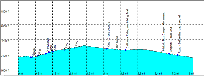
Borrego Springs: Rainbow Canyon Loop

Rating *****
length 8.5 mile - 3 hour 40 minutes (Round trip). Moderate.
Height 2230 - 3100 feet
Access Accessible by all Cars from the S2 close to Marker 27. Park at a large parking area on the east side of the road.
Other Trails
Data To download these files, right-click the link and choose 'save as' |--| .GPX (GPS file) |-----| .KML (Google Earth file)

  • Back

  • At the parking it is about 20 Min to the Rainbow Canyon Wash (go South East).
    Follow close to the road (down) or go (South East) cross country as we did, through a beautiful cactus "Forrest".
    Enter the sandy wash of Rainbow Canyon and head east - north east.
    The hiking is fairly easy on the whole stretch except for the part after "difficult".
    After this part there is as short stretch with dry rocky waterfalls, nothing too difficult but you may need your hands at times.
    As we near the end of the canyon, the canyon ends more or less and you have to go cross country (easy not too much vegetation), until hitting another wash that goes downhill on the other side of the mountain.
    Follow this wash down.
    At the point "Xing - cross country" go a bit left a couple of 100 yards out of the wash cross country (easy not too much vegetation) until you hit a dirt road of a primitive campsite.
    Follow this road until you hit the California Riding and Hiking Trail.
    Follow the CRHT left (west). You will get closer to the road, but the trail will go lower into a box canyon.
    When you reach the road (S2) again as the CRHT crosses the road, go left just before the road on a faint trail along the road.
    After a short stretch the trail goes left, away from the road in a wash towards the parking. Hiking Time 3 Hour 40 Min return.


    Efmer_Borrego_rainbow_canyon_loop

    Disclamer: Read this first before you start your hike.
    Contact: usa/at/e/f/m/e/r/.eu (leave out the /)
    All hikes recorded on pocket loox (pocket PC) using gpsTuner(.com)
    Hiking Hellhole Canyon Trail Borrego Springs Area (Anza-Borrego Desert State Park) California, Hike with gps, gpx and kml (Google Earth).