Borrego Springs picture
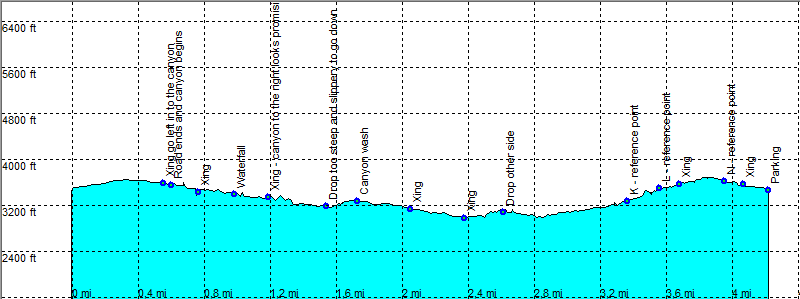
Borrego Springs: Pinyon Mine Wash Loop

Rating *****
length 4.5 mile - 2 hour 20 minutes (round trip). Moderate.
Height 2980 - 3680 feet
Access On Hwy 2 after mile 21 and directly after the Anza Borrego Park sign (from the direction of Borrego Springs) head left on a dirt road. Head East at the sign Pinyon mountain valley. Follow this dirt road in a high clearance (4x4) to the trail head.
Other Trails
Data To download these files, right-click the link and choose 'save as' |--| .GPX (GPS file) |-----| .KML (Google Earth file)

  • Back

  • At point A Xing the road runs strait into the canyon.
    Follow the canyon / wash downhill after some time we meet the main canyon / wash from the right (C Xing).
    The small drop at point D gives an idea what is to come.
    Just as everything looks ok we meet something at point F we dare not pass, a two stage (dry waterfall) drop.
    But there is an easy way around. Go back 50 Yards and head up the hill / canyon to the right (west).
    After a short climb there is a nice and easy wash that runs all the way to the canyon we couldn't pass.
    Take a look at the drop from the other side. It looks like you actually can make it.
    Go back to H Xing and continue strait on south west into a small rocky canyon, that is easy to follow up.
    More to the end of the canyon it becomes more cross coutry but still easy.
    On the other side we make it back to a small canyon, next to the dirt road.


    Efmer_Borrego_pinyon-mine-wash

    Disclamer: Read this first before you start your hike.
    Contact: usa/at/e/f/m/e/r/.eu (leave out the /)
    All hikes recorded on pocket loox (pocket PC) using gpsTuner(.com)
    Hiking Hellhole Canyon Trail Borrego Springs Area (Anza-Borrego Desert State Park) California, Hike with gps, gpx and kml (Google Earth).