Borrego Springs picture
Borrego Springs: Hellhole Canyon Trail

Rating *****
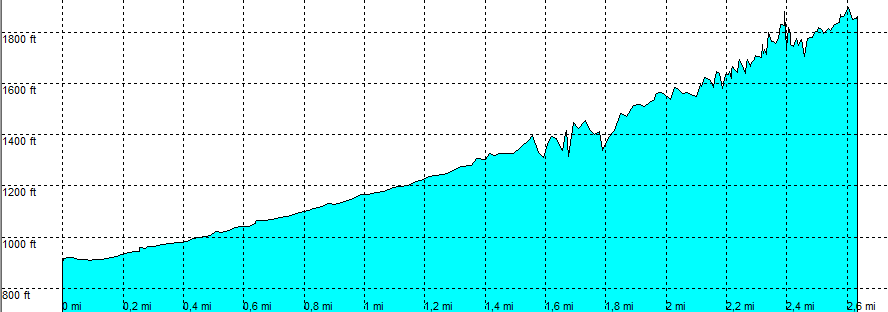
length 2.7 mile - 1 hour 25 minutes (one way). Moderate.
Height 900 - 1890 feet
Access All Cars, all paved. On Montezuma Valley Road, 1 mile south of the Visitor Centre, park in the parking area.
Other Trails California Riding and Hiking Trail
Data To download these files, right-click the link and choose 'save as' |--| .GPX (GPS file) |-----| .KML (Google Earth file)

  • Back

  • At the parking, head west, at a well marked trail head.
    The canyon can be seen strait ahead, crossing the California Riding and Hiking trail that bends to the left.
    At [3] crossing a trail from the Visitor Center (from the right). Move along and often across the wash coming out of the canyon.
    At times the trail is difficult to find, but take time to look for the easiest way.
    The end is obvious at the Maidenhair “falls” where water only flows when rain has fallen, so not too often.

    The end is obvious at the end of the year, but not always in spring, when there are 2 falls close to the end (as in March 2009) and some hikers stop at the first fall and never make it to the maidenhair that is only about 100 Yards further. The hike was completely different form the one we made half a year earlier.
    In March 2009 it was almost like a tropical rain forest close to the water. Birds, insects, lots and lots of wildflowers and green.


    October.


    Same hike in March.


    Hellhole Canyon Trail

    Disclamer: Read this first before you start your hike.
    Contact: usa/at/e/f/m/e/r/.eu (leave out the /)
    All hikes recorded on pocket loox (pocket PC) using gpsTuner(.com)
    Hiking Hellhole Canyon Trail Borrego Springs Area (Anza-Borrego Desert State Park) California, Hike with gps, gpx and kml (Google Earth).