Sedona picture
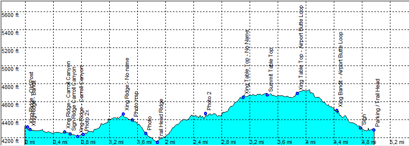
Sedona - Ridge Airport Bandit Loop

Rating *****
length 5 mile - 2 hours 20 minutes (round trip). Moderate/Easy.
Height 4160 - 4720 feet
Access All Cars, Take Shelby Drive and almost to the end take the parking on the right (2155 Shelby Drive).
Other Trails
Data To download these files, right-click the link and choose 'save as' |--| GPX (GPS file) |-----| KML (Google Earth file)

  • Back

  • Nice loop with views, Ocotillo and lots and lots of cacti.

    Look for the sign trail head parking. At this point take a small path that almost immediately goes left.
    After a couple of yards you see the sign to trail head parking. To the left is the actual trail head.
    Follow the Ridge Trail that is well marked.
    About 600 Yards before the end of Ridge trail the trail goes 90 degrees to the right as an unmarked trail leads strait ahead (there is also a stone marked trail). This unmarked trail is where you continue the loop. But first go down to the Ridge trail head, if you are lucky you see the Ocotillo blooming in April / May or turn yellow at the end of the summer. The trail ends on a gravel road.
    Go back to the crossing of the trail with no name, that leads in the direction of airport butte (east). First take a quick look at Table Top, a short flat hike with great views.
    Continue the hike until you reach the Airport butte trail. Go left until the crossing with Bandit. Go left on Bandit and continue straight on to the car.

    There is little shade on this hike.


    09_Efmer_Sedona_ridge_airport_bandit_loop

    Disclamer: Read this first before you start your hike.
    Contact: usa/at/e/f/m/e/r/.eu (leave out the /)
    All hikes recorded on pocket loox (pocket PC) using gpsTuner(.com)
    Hiking Ridge Airport Bandit Loop Sedona Arizona, Hike with gps, gpx and kml (Google Earth).