Sedona picture
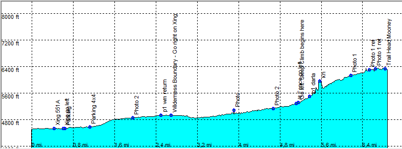
Sedona - Mooney Trail

Rating *****
length 14.1 mile - 6 hours (round trip). Hard.
Height 4470 - 6320 feet
Access From Sedona take Hwy 89A to Cottonwood. Exit FR 525 about Mile 364 on the right. Follow FR 525 - FR 525C after about 8.7 Miles from the Hwy you reach the trail head. The road is normally good and can be driven by any car up to the trail head.
Other Trails
Data To download these files, right-click the link and choose 'save as' |--| GPX (GPS file) |-----| KML (Google Earth file)

  • Back

  • Nice trail that climbs over a ridge goes through a canyon and climbs up to the top of a hill.

    The trail head sign is just after Black Tank on the right. This is FR 9551 (see photo).

    You can drive along the road on a high clearance car as far as you like or stop at the wilderness boundary but you will normally make it only to "E Parking".

    At "B Parking" follow the jeep trail north east.
    Keep on the 551A.
    At point "D" go left as the road straight through dead ends.
    The road is normally ok up to this point but gets more challenging by the minute to drive on.
    The road goes up more steeply and stays on climbing over a ridge until you reach the top of the ridge. Go on until you reach a road block, the wilderness boundary.
    Up until now the wilderness boundary was real close to the road on the left.

    After the Wilderness boundary, take the right jeep trail, this one becomes more like a hiking trail and goes a bit downhill.
    Goes into a canyon and passes the creek a lot of times.
    At Point "K" in the canyon, you pass some old barbed wire fences.
    Only if you are feeling real fit and are in a good condition go further.

    Here the real climb to the summit begins on a real rocky trail steeply uphill.
    The path gradually narrows and goes a bit less steep and goes on a ledge along the mountain.

    It gets real steep on the right hand side and my "afraid of heights" started to kick in.
    The trail is excellent, less rocky, but gets more narrow and steep on one side, with nice views. You get the feeling that you are high in the mountains.

    The end is not so spectacular, you meet the unmarked Casner Mountain trail and the Taylor Cabin tail on the other side. Some nice views on the other side.

    Expect a lot of rocks on the trail making the hiking even more difficult downhill.
    So wear good high (mountain for rocks) hiking boots and take a hiking stick along, it looks as if it is only for the elderly, but believe me once with it, you don't want anything else.
    It's great for the knees and is excellent on slippery stretches downhill to keep your balance.

    On the hike there is very little shade except for a short break.
    Hiking Time: 6 Hours return. You can subtract 30 Minutes return if you can make it up to "E Parking".
    Hiking Time: 2 Hour return to the Wilderness Boundary, point "H"


    09_Efmer_Sedona_mooney_trail

    Disclamer: Read this first before you start your hike.
    Contact: usa/at/e/f/m/e/r/.eu (leave out the /)
    All hikes recorded on pocket loox (pocket PC) using gpsTuner(.com)
    Hiking Mooney Trail Sedona Arizona, Hike with gps, gpx and kml (Google Earth).