Sedona picture
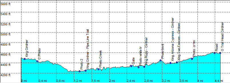
Sedona - Girdner Trail

Rating *****
length 9.2 mile - 3 hours 40 minutes (round trip). Easy.
Height 4200 - 4600 feet
Access All Cars, From Sedona take Hwy 89 Cottonwood, go right onto Cultural Park Place. Park at the end of the Red Parking lot on the right.
Other Trails
Data To download these files, right-click the link and choose 'save as' |--| GPX (GPS file) |-----| KML (Google Earth file)

  • Back

  • Nice hike in a hilly terrain, along dry creek.
    The trail starts at a picnic table with a large roof.
    Girdner is easy to follow up to the end at Dry Creek Road at the point where Vultee Arch rd (forest road 152) begins.

    A bit of of a forgotten hike along dry creek.
    It may be impassible when the water is high, as you pass dry creek a couple of times.
    (in April 2009 there was hardly any water. All crossings where dry.)
    There is shade on parts of the hike.


    09_Efmer_Sedona_girdner

    Disclamer: Read this first before you start your hike.
    Contact: usa/at/e/f/m/e/r/.eu (leave out the /)
    All hikes recorded on pocket loox (pocket PC) using gpsTuner(.com)
    Hiking Girdner Trail Sedona Arizona, Hike with gps, gpx and kml (Google Earth).