|
| Sedona - Cockscomb Trail |
| Rating | ***** |
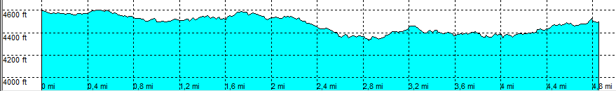
| length | 5 mile - 2 hour 15 minutes (round trip). Moderate. |
| Height | 4610 - 4340 feet |
| Access | All Cars, all paved. Boynton Pass Road, parking 0.2 Miles before start trail. |
| Other Trails | Across the road: Fay Canyon |
| Data | To download these files, right-click the link and choose 'save as' |--| .GPX (GPS file) |-----| .KML (Google Earth file) |